


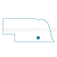
Glenvil Precinct, Clay County, Nebraska
About
Outline

Summary
| Unique Area Identifier | 612607 |
| Name | Glenvil Precinct |
| County | Clay County |
| State | Nebraska |
| Area (square miles) | 35.69 |
| Land Area (square miles) | 35.69 |
| Water Area (square miles) | 0.00 |
| % of Land Area | 100.00 |
| % of Water Area | 0.00 |
| Latitude of the Internal Point | 40.48094630 |
| Longtitude of the Internal Point | -98.22166810 |
Maps

Graphs
Select a template below for downloading or customizing gragh for Glenvil Precinct, Clay County, Nebraska


Neighbors
Neighoring Voting District (by Name) Neighboring Voting District on the Map
- Blaine Precinct, Adams County, NE
- L.L.L.M. CONS Precinct, Clay County, NE
- Leicester/Inland Precinct, Clay County, NE
- Pauline Precinct, Adams County, NE
- Spring Ranch/Fairfield Precinct, Clay County, NE
Top 10 Neighboring County Subdivision (by Population) Neighboring County Subdivision on the Map
- Fairfield township, Clay County, NE (598)
- Blaine township, Adams County, NE (497)
- Glenvil township, Clay County, NE (443)
- Hanover township, Adams County, NE (199)
- Little Blue township, Adams County, NE (193)
- Spring Ranch township, Clay County, NE (157)
- Lone Tree township, Clay County, NE (99)
- Inland township, Clay County, NE (94)
- Lynn township, Clay County, NE (60)
Top 10 Neighboring Place (by Population) Neighboring Place on the Map
Top 10 Neighboring Unified School District (by Population) Neighboring Unified School District on the Map
- Adams Central Public Schools, NE (5,278)
- South Central Nebraska School District, NE (3,474)
- Clay Center Public Schools, NE (964)